
Moradi Fm
Type Locality and Naming
25 km south-southeast of the mining town of Arlit (according to O’Keefe et al., 2005). Group: Izégouandane Gr (Upper)
References: Taquet, 1969; Valsardieu, 1971; de Ricqlès et al., 1982; Fabre et al., 1983; Sidor et al., 2003; O’Keefe et al., 2005; Sidor et al., 2005; Fabre, 2005; Damiani et al., 2006; Steyer et al., 2006; Smiley et al., 2008; Smith et al., 2009; Tabor et al., 2011; Tsuji et al., 2013; Sidor, 2013; Turner et al., 2015; Modesto et al., 2019; Abd Elmola et al., 2020; Web-01; Web-03.
Synonym: Unité d’Aokaré (for the upper Aokaré Mbr)
Lithology and Thickness
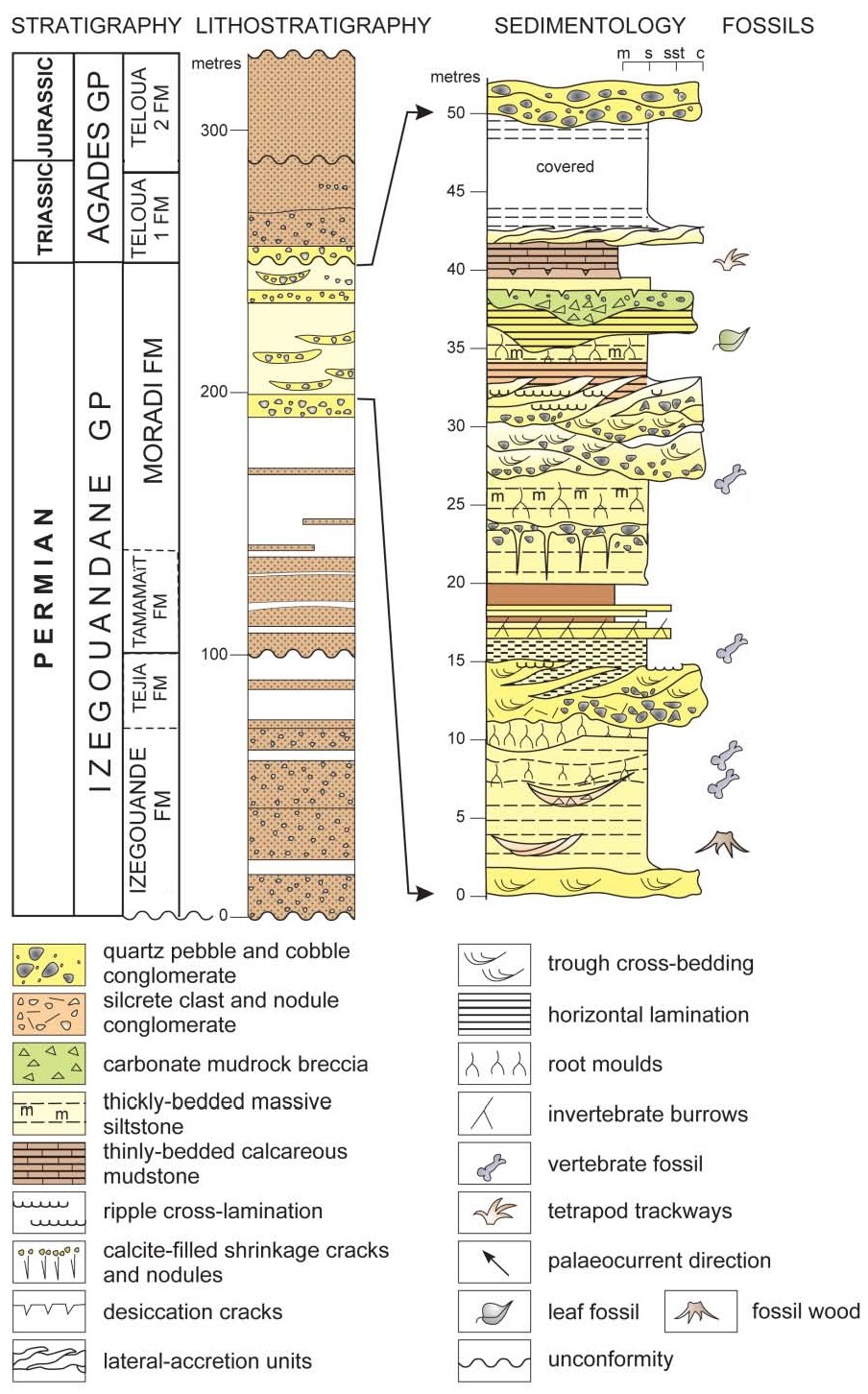
The Moradi Fm is a typical alluvial redbed succession dominated by red mudrocks with fine to coarse-grained pebbly channel sandstones and matrix-breccias (Tabor et al., 2011). The red color of the Moradi Fm is attributed to the presence of hematite (Abd Elmola et al., 2020), characterized by thick, friable, dark reddish-brown mudrocks interspersed with beds of an indurated, matrix-supported conglomerate (O’Keefe et al., 2005). Argillites with volcanic material. Joulia (1959a) and Wright et al. (1993) interpreted five depositional facies as (1) minor coarse-grained alluvial fan deposits, (2) common fluvial sandstones deposited in axial streams, (3) common fine-grained overbank/floodplain mudstones, (4) rare fine-grained sabkha mudstones and carbonates and (5) rare eolian sand dunes. The lower part of the Moradi is composed of rubified mudstone with interbedded lenses of calcareous muddy sandstone and quartz-granule conglomerate. The Middle Moradi unit (Aokaré Mbr?) consists of thick beds of muddy siltstone interbedded with red argillaceous sandstone. The upper part of the Moradi (Teloua 1 Mbr) (Fig. 1, Fig. 2) is composed of red siltstones intercalated with linear intraformational channel lag conglomerates in the lower two-thirds of the unit, and toward the top, barchanoid-shaped lenses of conglomeratic sandstone with ventifacts (Smith et al., 2015) (Fig. 3). Its thickness is 100 m (Smith et al., 2009).
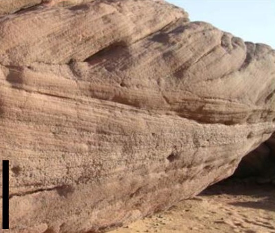
[Figure 1: Trough cross-bedded pebbly fine-grained sandstone of the lower point bar facies in the upper part of the Moradi Fm. Scale bar = 0.5 m (Source: Modified from Smith et al., 2015)]
[Figure 2: Stratigraphy, lithostratigraphy, sedimentology, and fossils of the upper part of the Moradi Fm (Source: Modified from Smith et al., 2015)]
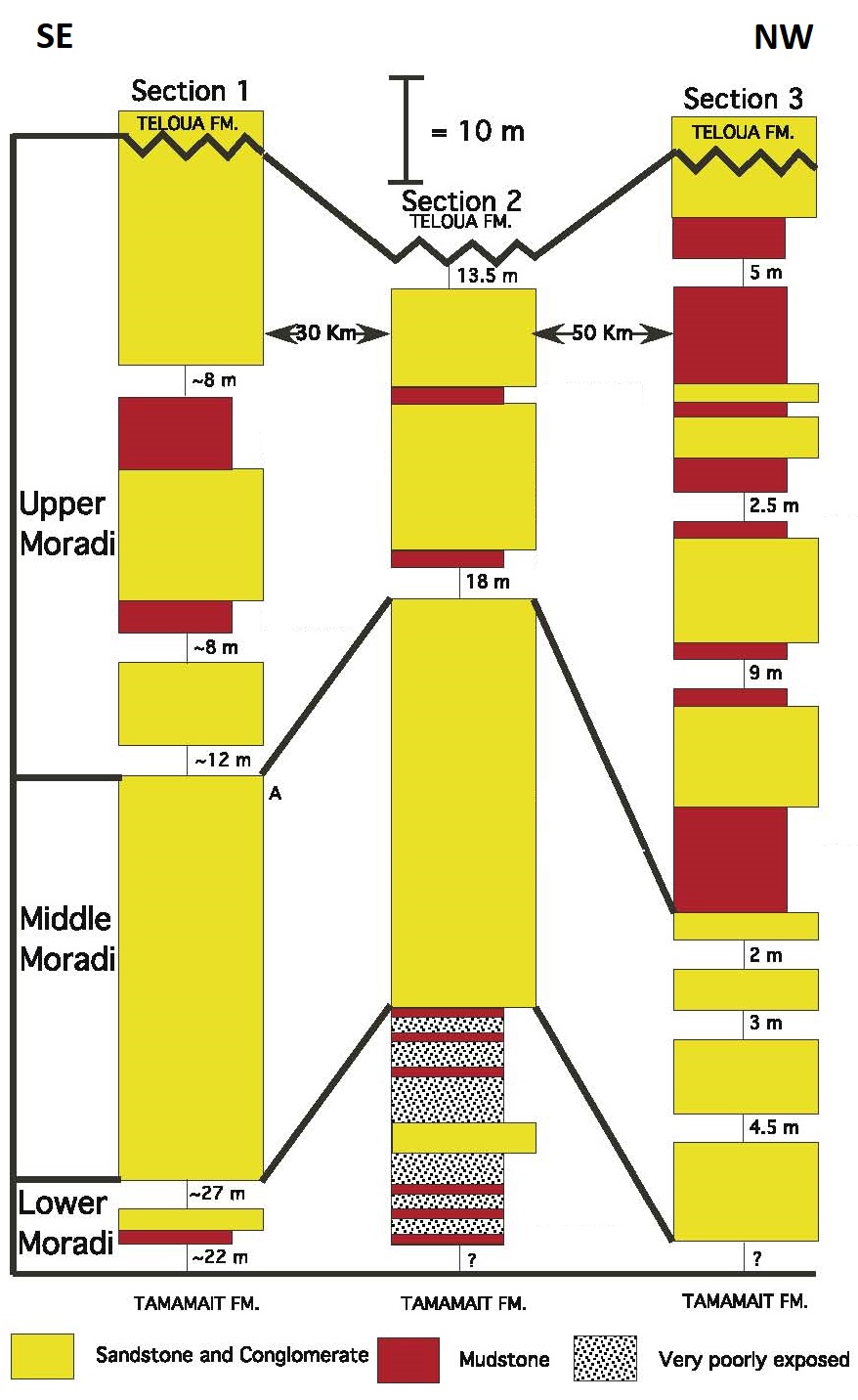
[Figure 3: Schematics of measured stratigraphic sections in the Moradi Formation (Source: Modified from Tabor et al., 2011)]
Relationships and Distribution
Lower contact
Underlying unit is the Tamamaït Fm
Upper contact
Overlying unit is the Teloua Fm
Regional extent
GeoJSON
Fossils
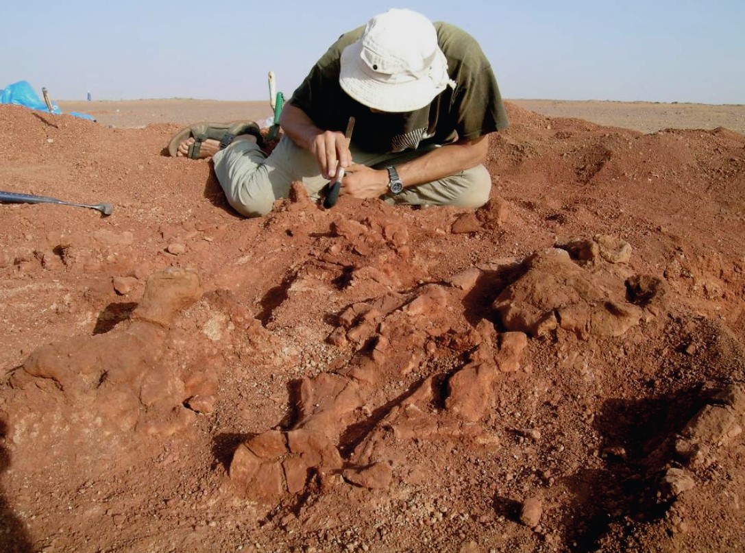
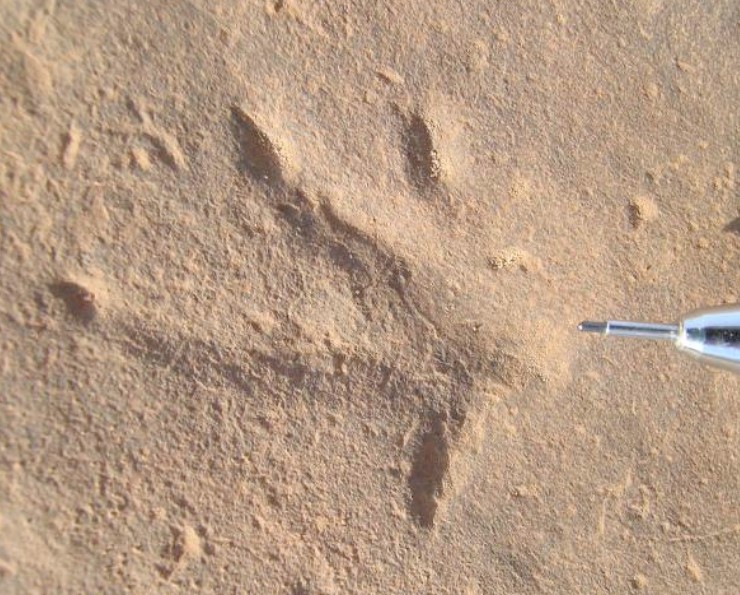
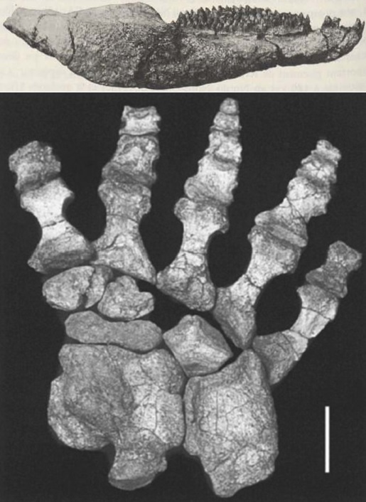
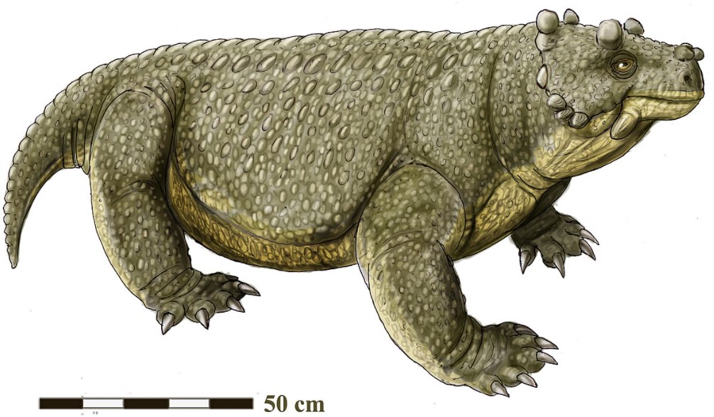
Fossil woods (tree trunks as long as 10 m). Cotylosauria, the oldest reptiles of the order Anapsida, were found in the clayey sandstones. These appeared in the Carboniferous 360 million years ago and later divided into Captorhinomorphs including Moradisaurus grandis Taquet (Fig. 6) and Diadectomorphs, the largest of which were the Pareiasaurids, herbivores represented by the Late Permian Pareiasaurus, reaching 3 meters in length (Taquet, 1969; Fabre et al., 1983) and Bunostegos akokanensis (Sidor, 2003; Smith et al., 2009, (Fig. 4); Tsuji et al., 2013; Turner et al., 2015) (Fig. 7). The Therapsids are represented by Gorgonopsian material found at 18° 31.113'N, 7° 33.186'E, approximately 20 km west of Arlit (Smiley et al., 2008). The amphibians are represented by Nigerpeton ricqlesi (Sidor et al., 2005; Steyer et al., 2006; Sidor, 2013; Web-01) and Saharastega moradiensis (Sidor et al., 2005; Damiani et al., 2006), the latter having been found at 18° 47.515’N, 7° 11.160’E near Ibadanane, approximately 20 km due west of Arlit. Tetrapod trackways of Limnopus, Dromopus (Fig. 5), Hyloidichnus, Hyloidichnus and Plantigrade have also been found (Smith et al., 2015). Black, phosphate-rich spiral coprolites, small non-marine bivalves (Palaeomutela sp.), and their burrows are locally abundant (Smith et al., 2015).
[Figure 4: Bunostegos akokanensis skeleton (Paleontologist Chris Sidor working on the skull) (Smith et al., 2009)]
[Figure 5: Small trackway tentatively ascribed to Dromopusor or Rhycosauroides (Source: Smith et al., 2009)]
[Figure 6: Top: Mandible of Moradisaurus grandis Taquet (Taquet, 1969; similar pictures are also found in Modesto et al., 2019). Bottom: Reconstructed adult right pes of Moradisaurus grandis (Source: O’Keefe et al., 2005)]
[Figure 7: Reconstruction of Bunostegos akokanensis (Web-03)]
Age
Depositional setting
Continental. Alluvial-fluvial-floodplain-sabkha-eolian. The Moradi sediments accumulated on a flat, semi-arid to arid alluvial plain with large, low angle gravelly alluvial fans prograding from the tectonically active Aïr Massif to the east. The vertebrate fossil-bearing upper portion of the formation was deposited episodically by overbank flooding of meandering streams that flowed into a closed, semi-arid continental basin. Although the rivers were sourced in more humid uplands, paleopedogenic carbonate and gypsum-bearing horizons in the Moradi floodplain sediments are an indication that climatic conditions in the lowlands were much warmer and drier. However, there is evidence that for a short period, a large stable, and perhaps perennial, meandering channel system generally flowed northwards along the axis of the basin. This possibly reflects a pluvial period lasting several decades of a more humid climate (Smith et al., 2009).
Additional Information